Magpie Falls (Serge is on the right)

Magpie Falls (Serge is on the right)
Aug. 3, 2010

Tuesday, August 31, 2010

Day 66 Another Picture Perfect Day (Lower Barney’s River NS, Lake Ainslie, NS)

As the title says, another picture perfect day for riding. Today’s route was 103 miles long with some good climbs and took us on to Cape Breton Island at the northern tip of Nova Scotia.

Before heading off the mainland, I took a quarter mile side trip through the woods to see a cairn erected to commemorate some Scotsmen who survived the Battle of Culloden in 1746 and immigrated to Nova Scotia shortly afterwards. On my way back to the road, I was quite surprised to see one other rider who decided to make the pilgrimage to the cairn.

Once on Cape Breton, we started climbing again. I managed to break another rear drive-side spoke, with 40 miles to go, but my wheel remained true enough to keep riding. Once back in camp I fixed my wheel, and also the real wheels of two other riders who had also broken rear spokes. It seems that I am getting pretty good at this if I say so myself…


After dinner we were treated to yet another spectacular sunset.
We are all anxiously watching the weather since the remnants of Hurricane Earl are predicted to be blowing through the Gulf of Saint Lawrence at approximately the same time as our 14 hour ferry ride to Newfoundland. My bet is that with all the luck we have had so far weather-wise, it will skip us. If not we’ll see what happens...

Tomorrow is a very hilly day of riding up the North Eastern side of Cape Breton. Off to bed now as we have 85 miles to ride.

I am not sure what the internet access will be like over the next few days so this may be my last posting until I return to New Jersey next Monday.

Day 65 Back on the Mainland (Cornwall PEI – Lower Barney’s River, NS)

Posted on Aug 31, Lake Ainslie NS

Another ferry ride this morning, so we started off on another “time trial” to catch the ferry at 11:15 AM – the next sailing was at 1:00 PM so we didn’t what to hang around for that. A few shots of the Eastern (Southern?) part of PEI along the way, but after that it was basically heads down riding, looking forward to the hour-long rest on the ferry ride.

Once on shore, we landed in our 9th Province, Nova Scotia.

I took side trip to Pictou, to see the Hector, a tiny ship which sailed with 200+ Scottish immigrants Nova Scotia in 1773. I can’t begin imagine what it must have been like to be on board with that many people, crossing the North Atlantic in September… and I thought my tent is crowded after 9 weeks of camping!

The day ended with another great sunset – the mosquitoes apparently know when to feed, as they were feasting on us as we were all taking pictures of the sunset.

Day 64 – The Big Red Mud (Murray Beach, NB – Cornwall, PEI)

Posted Aug 31 from Lake Ainslie NS
We got to sleep in this morning (‘til 6:45) because 10 miles into today’s ride we had to take a shuttle across the7 mile long Confederation Bridgeto PEI. Shuttle service began at 8AM and took 15 cyclists at a time. We figured about 45 minutes round trip, so if you weren’t first in line, you were in for a long wait anyway. We arrived around 9:30 and were queued up on the shuttle (which could only take 7 bikes at a time for 11:30. One of the riders has a recumbent which required a special truck to take it across, so we managed to hitch a ride with that, and got to the other side early (11ish). The bridge is privately owned, cost $1B to build 13 years ago, and the company owning the rights has to turn it over to the Canadian Government after 35 years. I did a quick mental math calculation, anc cannot for the life of me figure out how the investors will get their money back.

PEI is the 8th Province of our trip so far so here is the compulsory shot (actually we missed the "Welcome to PEI" sign at the end of the bridge, so this is a shot from the next day, just before leaving on the ferry!)

Once on PEI, we (Pierre-Alain and I) opened up the map and decided to head up to the north shore to check things out. After looking at the map of Ontario which took us 3 weeks to cross, it was a bit daunting to look at the map of PEI and think we could go across it in a little over an hour, but that is what we managed to do. We then looped back into Charlottetown (or Charlatan as the locals pronounce it) to tour the Confederation Hall where Canada was officially formed as a country in 1867. After a great ice cream, it was then off to the campsite for an end to a long day.

For those of you wondering about the title of today’s blog, PEI is famous for its potatoes which grow in a muddy red soil (both immortalized in a Stomping Tom Connor’s Song “Bud the Spud”).

Day 63 – Heads and Tails (Saint Louis de Kent, NB – Murray Beach, NB)

Morming - Feeding time for the mosquitoes
Posted Aug 31 from Lake Ainslie NS

We started off the day with an amazing sunrise and swarms of morning feeding mosquitoes to assist us in our preparation of breakfast. This was our last meal to cook for the group, and our last day as sweep too!.

I decided to take the most circuitous route to Murray beach, basically looping along the coastal road at every opportunity. My first loop took me to Cap Lumiere where I got a view of the Strait of Northumberland, and across it, the North Cape of Prince Edward Island, Canada’s smallest province. It continues to amaze me how far along Canada is with green technology, the horizon of the North Cape was covered with massive wind turbines, slowly churning out electricity for free!

One of the highlights of today was a small farmers market in Bouctouche, NB There were stalls with vendors selling everything from coffee to Indian food, and on stage there was a band of musicians,, the youngest probably 75 years old, playing Cajun music. Here is a shot of one of our riders playing with the band!

We stopped in Shediac NB, home of the mutant lobsters on which the movie Godzilla was based - they used a dinosaur instead.  After an hour stop there, I headed on and along the planned route. About 20 miles from the end, I looped once again along the coast, but this time was rather disappointed by the views. It did add enough mileage to the day to let me log another 100+ mile day though!

Sunset iver the Strait of Northumberland
The campsite was overlooking the Straight of Northumberland, and afforded a spectacular sunset before heading off to sleep (at around 8:30 – quite the exciting life for us cyclists.

Friday, August 27, 2010

Day 62 – In Search of Holes (Saint Louis de Kent, NB Rest Day)

After a rainy night, a buffet breakfast, and 90 minutes cleaning the filth off my bike and lubing it, it was off to the pool with my air mattress top try and find the hole(s) and patch them.

After what seemed like an eternity of holding it under water (I am sure some onlookers thought I was trying to drown someone) some miniscule bubbles appeared. The next task was to mark them so I could patch them later, then to dry the mattress and finally patch the holes.

Yet Another Sunny Day!!!
I patched the holes before lunch, rode two miles into Sainte Louis de Kent (the birthplace of the Acadian Flag) with Serge and P-A for lunch. After lunch, I tested out my repairs – apparently there are more than two holes in the mattress – off to the pool to try and find the others!!!


Side Note:   In our haste yesterday, unbeknownst to us at the time, Serge and I missed the turn off to the campsite from the main road, and 6 miles down the road figured out that we should take the next exit, even though it was not the same road as the one marked on the cue sheet. We spent the next 4 miles commenting on how poorly the cue sheets were written – not only did they get the mileage wrong, they got the road wrong!!! When we got to camp, we were first in for the day, arriving just after the truck. Our view was that the cue sheet couldn’t be too bad, because after all, we made it into camp.

When the other riders came in we asked them what they thought of the cue sheet, and its inaccuracies. We were pretty sheepish to learn that we had missed the turn, but managed to get in an extra few miles for the day.

Day 61 – Running out the Clock! (Petit Rocher, NB – Saint Louis de Kent, NB)

Morning SKies
Per the weather forecast we woke this morning, after a rainy night to threatening skies, it was not raining, but sure felt like it wanted to. It looked like our streak of 15 rain-free riding days was coming to an end.

After starting our early on the road (7:30 AM), we logged a quick 30 miles before stopping in Allardville for a 2nd breakfast. It turned out that “I’ll have what he is having” was a popular choice – the truck driver beside me had a plate of 3 eggs, bacon, ham, sausage, toast, potatoes and coffee. Apparently he had driven by us in the Matapedia Valley two days earlier, and was quite interested to see us, and to learn of our adventure.

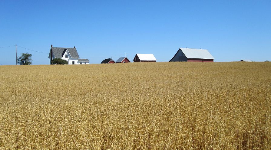
The route today took us across the peninsula forming the eastern tip of New Brunswick. The roads were great, fresh pavement and a wide shoulder for cycling on. With the weather (light rain, mist and high humidity) it did not make for a great day for taking pictures. After breakfast, Serge and I rode pretty much head down for the last 60 miles into camp. Our main goal was to get to camp early enough so that we did not have to wait in line for the laundry and showers prior to tomorrow’s rest day. Having seen vast amounts of salt water in the Baie des Chaleurs yesterday and this morning, we are beginning to realize that our ride/adventure is quickly drawing to an end, and there is prevailing mood amongst the riders of “running out the clock” like at the end of a game whose outcome has pretty much been decided. Despite that I am looking forward to seeing, and cycling Prince Edward Island, Cape Breton Island (whose hills are apparently some of the tougher of the tour), and finally “the rock” or Newfoundland.

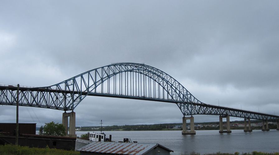
Looking down on the Mirimachi
One of the more interesting parts of the route was crossing the Mirimachi River Bridge. It was quite high, and looks much higher than it felt from the river bank.
Looking up at the Bridge.

We were on cooking duty tonight, and the meal was lobster (pre-cooked, thank God, and supplied by the father of a rider from 1997.) After 3 night of white rice, and a 4th one planned for this evening, we went “off-menu” and prepared a satay noodle side dish from memory. It was greatly appreciated by the group.

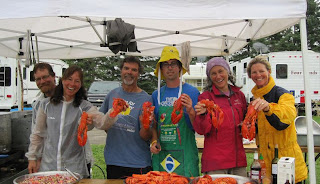
A fun crew to work with after long days of riding.
Tonight was our last night on cooking duty, so “Team One” posed for a team picture, lobsters and all. Just before eating, Mark (in the yellow sou’wester hat), whose home is in New Bruinswick, gave a demo/lesson to all in how to efficiently eat a lobster (and just as importantly for some who had never eaten lobster before, what parts were edible, and what were not).


Having finished my laundry before dinner, my rest day tomorrow will be spent cleaning and lubing my bike, and trying to find and patch the holes in my air mattress. For the past 10 days, its inflatable life was around 3 hours which meant re-inflating it several times in the middle of the night so I could sleep comfortably.

Wednesday, August 25, 2010

Day 60 The Baie des Chaleurs (Atholville, NB – Petit Rocher, NB)


After an early start (mainly a side-effect of advancing our watches ahead one hour yesterday). No, the town we left from this morning was not named by someone with a lisp!

Our route today took us along the southern side of La Baie Des Chaleurs in the Gulf of Saint Lawrence.

Our first town was Campbellton, NB on the Restigouche River, another famous salmon fishing river on the Gaspe, as you can see from the statue by the river.


Calm Waters
It was another day of great weather, with spectacular views of the Gaspe Peninsula.


Today’s ride was one of the shortest of the last few weeks, yet I managed a few short side trips to explore what looked like good “photo-ops.”

Something about the wheat that I couldn't resist!
We finished the 62 miles early, rolling into camp around noon. For a change we got to set up our tents ion a relaxed manner, cook some lunch by the truck, shower and shave, and do a quick wash of the bike clothes.

View from the tent!
As you can see, great views of the Baie des Chaleurs from the campsite.  The weather forecast for tomorrow is rain.  A bit of a bummer, but so far we have only had 7 days of rain since the start - we met some riders from last year's tour who informed us that they had 54 days of rain out of 72 days of riding, so no complaints from here - not that complaining would make a difference anyway.

Day 59 – The Matapedia (Saint Damase QC – Atholville, NB)

Posted from Petit Rocher NB Aug. 25th

Today, for the first time camping since BC, we were not awakened by the sound of zippers on sleeping bags or tents unzipping. Apparently the campsite was located near the Canadian testing grounds for 2-cycle engines, and the testing and incessant high-pitched whining of the motors began at 5:00 A.M.

Our route today took us over the northern tip of the Appalachian Mountain Range and then down along the valley of the Matapedia River, one of the world famous salmon fishing rivers in this part of Quebec. Clear blue skies and sunny weather made for another great day of riding.


It seemed that every two miles or so presented another photo-op. One of the amazing parts of the route was investment that the Quebec government has made in cycling paths in the area. They already have a lot of dedicated shoulders alongside the roads, and are in the process upgrading the shoulders to accommodate lanes in both directions.
Work in Progress
The finished product


The river views were amazing, heavy forests up the mountainsides on each side and wide clear waters.

The Matapedia
We got to ride through two covered bridges along the route – when riding through them the wood absorbs all the ambient noise and it is eerily quiet - quite the difference from the trucks rolling by us on the pavement.

I got stung by another wasp today, at mile 50 - this time in the inside of my mouth. That will teach me to keep my mouth shut!!! For the rest of the ride, my lower lip was swollen and numb, kind of like coming home from the dentist.

We left Quebec at the end of the day and rode into our 7th province – New Brunswick, and our 4th time change, setting our watches ahead one hour to Atlantic time.

A short 62 mile day tomorrow after 92 miles today..

Day 58 – Windpower (Trois Pistoles QC – St-Damase, QC)

Posted Aug 25th from Petite Rocher NB

Today started off with a major climate change – temperatures in the low 50s, and high humidity made for a cold which cut through every layer of clothing. We started out with a short 10% climb and then turned left directly into a headwind. There was a heavy layer of fog along the Saint Lawrence, but when we headed in-land the temperature rose 15 degrees to the mid 70s. Unfortunately, the weather patterns made for difficult clothing selection – we were either too hot when inland, or too cold when riding along the foggy shore.

Modern art
When I went to take my first photo, my camera decided to display “modern art” rather than the image that I was trying ti capture or the camera menu. Luckily 30 miles into the we arrived in Rimouski, a town large enough to have a shopping mall where I got a new camera. My choice was driven by compatible batteries, so I stuck with a Canon and got a 780 IS Digital Elph.

The route was mainly along the Saint Lawrence (and into a strong headwind). The most interesting part of the route was the fog over the river and along the shore. We stopped for lunch in a small town with a great view of the river. Afterwards we made our way along the shore, still cold from the damp headwinds.

Up from the Saint Lawrence
After 76 miles of riding, we headed inland and started the climb over the Gaspe Peninsula – the northern end of the Appalachian Mountains. It involved some pretty good climbs and some really fun descents, mainly climbing though.

For the last hour of riding, we were amongst a “farm” of wind turbines – the slow rotation of the massive blades was quite hypnotic, and provided some good entertainment for the end of the day.

Helping the moonrise!
We arrived at camp to summer weather, and great sites by the lake. We took advantage of the full moon over the lake to have some fun with our cameras.

Sunday, August 22, 2010

Day 57 – Nor’Easter (Riviere Ouelle, QC – Trois Pistoles, QC)

Looking at the cue sheet last night we figured that we were in for a relatively easy day – 72 miles of flat terrain, with a bakery at mile 20 and a micro-brewery at mile 25.

Fresh Baked Bread
Upon leaving the shelter of the campsite this morning, we realized that we were in for quite a different day. Overnight, the wind had shifted from a tailwind to a semi-classic Nor’easter blowing from 15 – 25 mph, with higher gusts, directly into our faces. The semi-classic part was that we thankfully did not get the driving rain that usually comes with a Nor’easter. Serge, P-A and I grouped together to ride in a pace-line, sharing the effort at the front. After a relatively easy pace for the first 20 miles, we stopped at a bakery in Kamouraska that one of the riders (Marc) had recommended. We were not disappointed, and it was the first “European” bakery that I had seen after over 4,800 miles of riding. The smell alone was worth the stop, but the almond and chocolate croissants (one of each) were even better.

Granite Islands in the Saint Lawrence River
After our 2nd breakfast, we headed back out on the road, and into the wind. The scenery today was spectacular, flat farmland with granite protrusions popping up out of nowhere.

A short ride up the road and it was time for our 2nd stop, just before 10:00 AM. Two other riders (Tom and Randy) had toured in the area previously, and insisted that we stop at a micro-brewery and order their sample pack.

After 25 miles of riding into the wind, our electrolytes needed to be rebalanced so we followed their recommendation – the beers were brewed in a Belgian style, and quite interesting, a blonde, a white with raspberry, a rose, a brown and a cabernet sauvignon. Our electrolytes in balance once again, we headed up-wind.

Headwinds!!!
After stopping for lunch at Tim Horton’s in Rimouski, we headed out once again into very strong (20+mph) headwinds, and threatening foggy weather. Since I had plenty of energy, I took more than my share at the front and pulled at a good pace (16+mph) for more than half of the remaining 30 miles into camp. We arrived shortly after 3PM and got to set up our tents in dry, buy very windy weather.

All in all one of the tougher days of the tour so far – in effect it was the equivalent of a 70 mile hill climb. On the positive side, it was not raining and it strengthened our legs for the climbs on Cape Breton Island.

It is hard to imagine that we only have 2 weeks of riding left before it all comes to an end in Newfoundland.

Saturday, August 21, 2010

Day 56 – Extra Miles - Again! (Quebec City QC – Riviere Ouelle, QC)

Bike paths!!!
Quebec City is an amazing area for cyclists – a great network of dedicated bike paths connecting all the major sightseeing areas.

Les Chutes de Montmorency
After a quick breakfast at the cafeteria of the Universite de Laval, where we were staying on our rest day, Serge, P-A and I decided that we would take a sightseeing tour at the start of the day to see the Montmorency Falls. This added 20 miles to the planned 86 miles for the day, but was well worth the extra effort, including a 10 mile ride into a strong head wind back to the ferry. The falls are 50% higher than Niagara Falls, but without all the kitschy development.


Stairs, Anyone?
At the falls we opted to climb the network of stairs to get to the top, rather than shell out the $12 for the cable car. Our legs were in great shape so we made it to the top quickly and without breaking a sweat.

Not for those who are afraid of heights!
The Suspension Bridge spanning the top of the falls allowed us to look straight down the 250’ drop!

Quebec City
We crossed the river by ferry to Levis at noon, some 3 hours after passing it on the way to the falls. On the river we had some pretty spectacular views of the city – it is as close to Europe as you can get in North America and without all the jet lag.

The Saint Lawrence River
Once on the south shore we headed east down river with a nice tailwind. We stopped at a "Casse Croute" for lunch with some great views alongside the river.

After a great, but long ride, with tailwinds, we pulled into camp at around 5:30. This was my nineteenth 100+ mile riding day since the start of the tour.

Thankfully tomorrow’s route is only a short 71 miles, but who knows how that will turn out as its is “Not Yet!”

To put things in perspective for my riding friends in New Jersey, we are now due north of Maine, and still have 1,000 miles of riding left (probably much more with all the side trips we are doing).

To date I have logged almost 7,000 miles of riding for the year (6,965 to be exact), and over 4,800 miles since arriving in Vancouver.

I am not sure what the network access will be like over the next few days, but will try to keep everyone current. 

Cheers, it is 9:30 and I am off to a well earned sleep - the nights are getting cooler as we get closer to the Atlantic, and closer to September - thankfully we appear to have avoided the summer heat wave.

Day 55 “Ago”, “Now”, and “Not Yet!” (Quebec, QC Rest Day)

By now you are familiar with the usual Rest Day’s activities – copious consumption of food, laundry, bike tweaking, and some sightseeing – so I thought I’d enlighten you on our perspectives of time after 55 days on the road.

With a change of venue each night, and riding different routes each day, unless you refer to pictures (or probably my blog) it is very difficult to remember when, or where a specific event happened. For example, I know that I trued a rider’s wheel after her water bottle fell into it, but with all the new adventures each day, cannot specify where, or when this happened.

Apparently this is a common feeling amongst the riders – we know what happened today, and if we try hard, yesterday or the day before, but other than that the best we can do is that it happened “ago” as in “some time ago”. One fun exercise is to ask our fellow riders to name the last 10 campsites/cities we stayed in, in order – few if any can get beyond the last 5 without major effort.

As such our perspectives of time have changed greatly since leaving Vancouver. We are not exactly sure of the day or date, we just know for example that today is “Quebec - Rest Day”. If pressed we could go through a mental exercise to figure it out, or check one of the few watches that people are wearing, but for the moment, it just doesn’t matter. Our time references are, as today’s title says: “Ago”, “Now”, and “Not Yet!”

I am beginning to wonder how long it will take us to readjust once we are back at home.
Vieux Quebec

We finished off “now” with a nice stroll through Quebec, walking up and down the cobblestone streets, and a wonderful dinner on the terrace of a small bistro in Quebec City!

Dinner on the terrace

Tomorrow, (or “not yet”) we cross over to the south shore of the Saint Lawrence River and head up the Gaspe Peninsula.

Day 54 – Sweep (Trois Rivieres, QC – Quebec City, QC)

Posted Aug. 21 from Rivierew Ouelle QC


Having a Blast!
Today, since we cooked for everyone last night (a great Boeuf Bourguignon, if I say so myself) and breakfast this morning, our cook team was responsible for sweeping the route. Given that, there was no pressure to leave camp early, or ride at a fast pace, so I stopped less than 2 miles from camp to visit the Saint Maurice Blast Furnace Historic Site, where I met Kelly and Judy from our cooking team. The site is a national historic monument of the remnants of the first blast furnace in North America, built in 1730. Unfortunately the buildings opened at 10:00 AM, but one of the workers, after we played our “we are riding our bikes across Canada” card, opened up the facility and gave us a private tour.

After successfully navigating our way out of T/R, we still managed to put down a pretty good pace (20+mph) and took advantage of it to make frequent stops. Our first was for a 2nd breakfast at a place with great views of the St. Lawrence River. After that we stopped to check out what was going on at a kennel breeding hunting dogs – again playing the “we are riding our bikes across Canada” card, and asking if they would mind giving us a tour. They were breeding English Springer Spaniels (my first and 2nd dog) and let a litter of eight 10 week old puppies onto us – it was an avalanche of fur, wagging tails, floppy ears and nibbling teeth, but lots of fun.

Next stop was at a small restaurant for lunch where I decided to repair my rear tire, the one I put on in Thunder Bay about 2,000 miles ago! It was thin and puncturing regularly, but the self sealant was working. I decided to throw in an inner tube so I could ride at a higher tire pressure than the 60 PSI it seemed to seal the leak at.

With a well inflated rear tire we were off again. About 5 miles out, Judy got stung on her neck by a wasp. I repeated my first aid from yesterday and we pressed on.

Along the route some TdC veterans from last year had prepared sweet corn for this year’s riders. Luckily Kelly was paying attention and noticed some of our riders at the stop – I was head down riding 20+mph focused on the next 50 feet of road at the front of the pace line, and Judy about 6” behind me – some sweep! We stopped for corn and to share our experiences with our hosts, and then headed off to Quebec for our 2nd to last rest day!

The route into Quebec took us up a steep hill (15% grade by my estimate) underneath a very large iron railroad bridge. The most amazing part of that was that an amputee cyclist riding a “hand crank” tri-cycle, cranked his way up. We gave him a big cheer when he got to the top.

We ended the day in “Le Vieux Port” of Old Quebec replenishing our fluids and carbohydrates at “le festi-biere” where we sampled more than our fair share of micro-brewery products.